
![My new company offered me a car & Fuel card in my contract. Made me redundant after 5 months and never supplied me with a car. When are my rights? [closed]](https://cdn.sstatic.net/Sites/workplace/Img/apple-touch-icon@2.png?v=d39b333f5c58)


Sols 4445–4446: Cloudy Days are Here
Earth planning date: Wednesday, Feb. 5, 2025 Overnight before planning today, Mars reached a solar longitude of 40 degrees. The solar longitude is how we like to measure where we are in a Mars year. Each year starts at 0 degrees and advances to 360 degrees at the end of the year. For those of […]
4 min read
Sols 4445–4446: Cloudy Days are Here

Earth planning date: Wednesday, Feb. 5, 2025
Overnight before planning today, Mars reached a solar longitude of 40 degrees. The solar longitude is how we like to measure where we are in a Mars year. Each year starts at 0 degrees and advances to 360 degrees at the end of the year. For those of us on the Environmental Science (ENV) team, 40 degrees is a special time as it marks the beginning of our annual Aphelion Cloud Belt (ACB) observation campaign. During this time of year, the northern polar ice cap is emerging into the sunlight, causing it to sublimate away and release water vapor into the atmosphere. At the same time, the atmosphere is generally colder, since Mars is near aphelion (its furthest distance from the Sun).
Together, these two factors mean that Mars’ atmosphere is a big fan of forming clouds during this part of the year. Gale is right near the southern edge of the ACB, so we’re starting to take more cloud movies to study how the ACB changes during the cloudy season. (Jezero Crater, home to Perseverance, is much closer to the heart of the ACB, so keep an eye on their Raw Images page over the next several months as well.
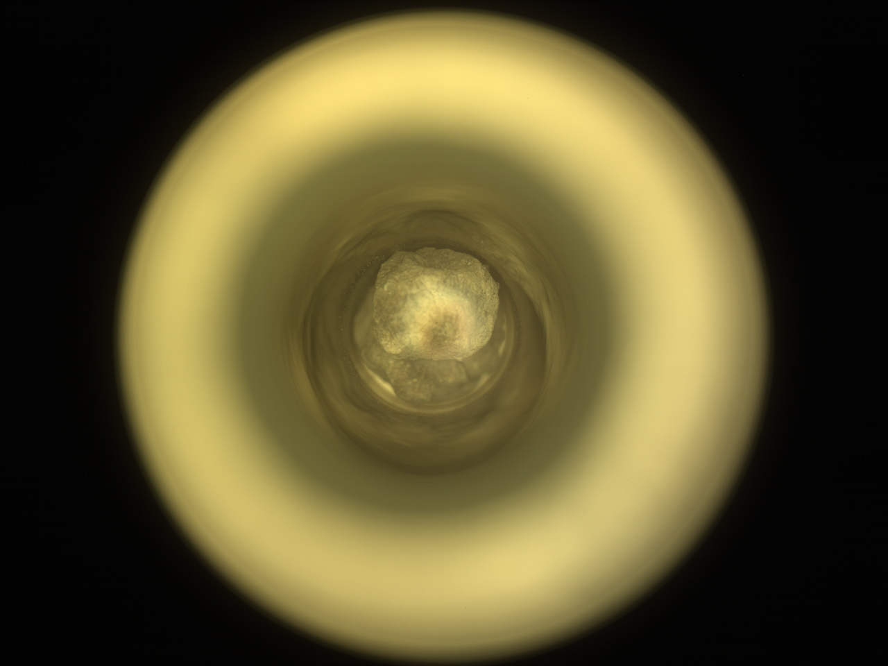
The drive from Monday’s plan ended early, after just about 4 meters instead of the 38 meters that had been planned (about 13 feet vs. 125 feet). We initially thought this might have been because our left-front wheel ran into the side of a large rock (see the image above), but after we got our hands on the drive data, it turned out that the steering motor on the right front wheel indicated that a rock was in the way on that side too, so Curiosity stopped the drive to await further instruction from Earth. This is a well-understood issue, so we should be back on the road headed west today.
The cold weather is still creating power challenges, so we had to carefully prioritize our activities today. Despite the drive fault, we received the good news that it was safe to unstow the arm, so we were able to pack in a full set of MAHLI, APXS, and DRT activities. Before that, though, we start as usual with some remote sensing activities, including ChemCam LIBS and Mastcam observations of “Beacon Hill” (some layered bedrock near the rover) and a ChemCam RMI mosaic of the upper portion of Texoli butte.
After taking a 3½-hour nap to recharge our batteries, we get into the arm activities. These start off with some MAHLI images of the MAHLI and APXS calibration targets, then continue with MAHLI and APXS observations of “Zuma Canyon.” This is followed by DRT, APXS, and MAHLI activities of some bedrock in our workspace, “Bear Canyon.” Although we then take another short nap, we don’t yet stow the arm as we have a pair of lengthy post-sunset APXS integrations. The arm is finally stowed about an hour and a half before midnight.
The second sol of this plan begins with some more remote sensing activities, starting with ChemCam LIBS on “Mission Point”. This is followed by a series of Mastcam images of “Crystal Lake” (polygonal fractures in the bedrock), “Stockton Flat” (fine lamination in the bedrock), “Mount Waterman,” and Mission Point. We then finish with some ENV activities, including a Mastcam tau and Navcam line-of-sight to measure dust in the atmosphere and a Navcam cloud movie. This plan ends with a (hopefully!) lengthy drive west and many hours asleep to recharge our batteries as much as possible before planning starts again on Friday. Of course, I would be remiss if I didn’t mention that REMS, RAD, and DAN continue to diligently monitor the environment throughout this plan.
Written by Conor Hayes, Graduate Student at York University